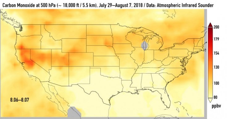
California's 2018 wildfire season has taken a severe turn as there are multiple fires throughout the state. The fires are so large and widespread that other parts of continental US are also bearing the brunt of these fires. NASA has released a report pointing out how the carbon monoxide levels are slowly climbing all through the country -- as far as the Eastern coast. This comes in addition to the smoke and ash released into the atmosphere.
NASA says that carbon monoxide can stay in the air for about a month and also be transported across massive distances in the meanwhile. The space agency has put together a few new images updated with data pooled by the Atmospheric Infrared Sounder (AIRS) on NASA's Aqua satellite, notes the release. In the image, high concentrations of carbon monoxide from wildfiresis shown in orange and red, this covers a time period between July 29 and August 8.
Over the weeks covered, carbon monoxide clouds that are high in the atmosphere is seen gradually drifting east. One branch is seen moving south toward Texas and the one branching off north east.
AIRS is built to measure carbon monoxide high up in the atmosphere. Up there, it has a negligible effect in the air people breathe on the surface. Strong winds, however are known to be able to carry it downward. Sometimes to spots where it can have a significant effect on the quality of air.
The series of images on display shows the distance that carbon monoxide that was released as a result of California's wildfires has travelled eastward. The maps also point out regions around the US where this could pose a greater risk for people.
Another NASA instrument that was used for this report and the study of carbon monoxide include the Measurement of Pollution In The Troposphere (MOPITT), which tracks carbon monoxide in the lower reaches of the atmosphere. NASA's Moderate Resolution Imaging Spectrometer (MODIS) can detect carbon monoxide over large areas of land.


