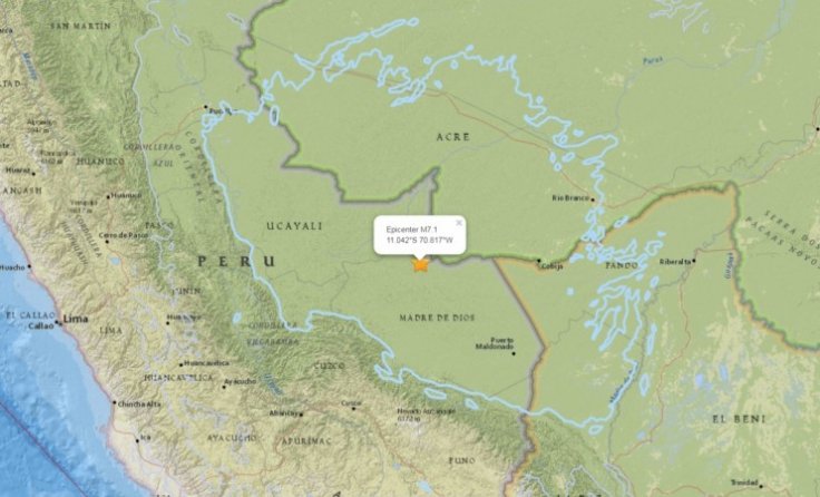
An earthquake of magnitude 7.1 in the Richter scale hit the region on August 24 where Peru shares a border with Bolivia and Brazil, according to United States Geological Survey (USGS) report.
USGS released a preliminary earthquake report that and mentioned that it happened in the early hours of Friday in Southeast Peru. The epicentre of the earthquake was 83 miles west of the Peruvian village of Inapari and 140 miles west of the Bolivian city of Cobija. The reason stated was "normal faulting at a depth of approximately 610 km."
No other information regarding damages or loss of lives has been reported yet. Express UK reports that the quake was also felt in northern Chile and the Colombian city of Medellin. However, authorities have said that there is no threat of a Tsunami at the time.
The USGS report further added, "This earthquake occurred within the oceanic lithosphere of the subducted Nazca plate, almost 1,000 km east of the Peru-Chile Trench. Focal mechanism solutions indicate that rupture occurred on either a northwest or southeast-striking, moderately dipping normal fault."
Subducting refers to a geologic process in which one of Earth's many tectonic plates slide underneath the other. The subducted plate is then forced by the upper plate to sink due to gravity into the mantle, which is a layer between the crust and the outer core of the Earth.
USGS then goes on to explain, "Slip on a fault of either orientation would accommodate the down-dip extension of the Nazca slab that is implied by the normal component of the faulting solution. At the location of the earthquake, the Nazca plate subducts to the east under the South America plate at a velocity of about 69 mm/yr."
USGS also revealed that very few earthquakes take place at depths between 200 and 500 km, where the Nazca plate is pushed beneath eastern Peru. However, the plate becomes seismically active again at depths of 500 to 650km.
Interestingly, USGS mentions that the part of the Nazca plate where the earthquake happened, took more than 10 million years for it to descend to those depths from the point where it originally went under the South American plate.
Being situated at the very boundary of the Nazca and South America tectonic plates is the reason why earthquakes in Peru are common. The USGS report also mentioned how 12 of 95 magnitude 7+ earthquakes in the past century have occurred at the same region as the August 24 earthquake.
Peru's quake comes a day after a magnitude 6.3 earthquake struck the Andreanof Island and the Aleutian Islands of Alaska. The quake has even rattled a volcano in the state located in Tanaga island.
Express UK provided the English translation of a tweet from Chile's Foreign minister Roberto Ampuero which read, "We have received information there was a strong 7.1 earthquake in southern Peru. We convey to our Peruvian brothers our solidarity and willingness to cooperate if that is required. A hug to Peru."


