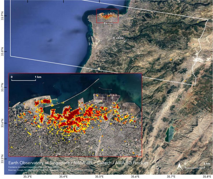
It was on August 04, 2020, that a massive explosion in Beirut port killed 157 people and injured more than 5,000. The video of the powerful explosion had gone viral on the internet, and it is now widely considered the most lethal blast ever caught on camera. Now, NASA, the United States space agency, has successfully mapped the Beirut explosion using data obtained from the European Space Agency's Copernicus Sentinel satellites.
NASA's Map Sheds Light on Ultimate Devastation
The new map is being prepared by the Advanced Rapid Imaging and Analysis (ARIA) team at the space agency's Jet Propulsion Laboratory at Caltech, in collaboration with the Earth Observatory of Singapore.
NASA, in a recent statement, revealed that such maps will help to understand the overall impact of the deadly explosion, and could also identify badly damaged areas where people are in need of any kind of assistance.
The space agency has prepared this map using three different colors. The areas marked in red are the most affected, and it might in these areas that people may need assistance. Areas marked in orange are moderately damaged, while yellow areas might have sustained less damage.
"Synthetic aperture radar data from space shows ground surface changes from before and after a major event like an earthquake. In this case, it is being used to show the devastating result of an explosion," wrote NASA in a recent statement.
A Risk Known for 13 Years
The huge stockpile of the fertilizers that exploded in Beirut was known as a risk for at least seven years. According to a report published in New York Post, 2,750 metric tons of the ammonium nitrate, most commonly used for terror attacks unexpectedly reached Beirut in 2013. The complete cargo was actually going to Mozambique, but the MV Rhosus, which was owned by a Russian man named Igor Grechushkin, halted its journey, as the businessman went bankrupt.


