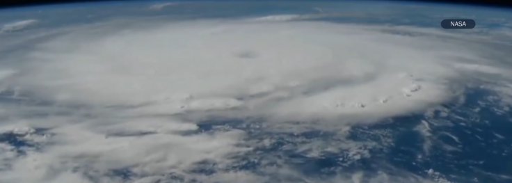
The International Space Station (ISS) has captured incredible footage of Hurricane Beryl's eye as it passed over the Caribbean on Monday morning. This powerful storm unleashed torrential rain, fierce winds, and severe flooding across the Eastern Caribbean.
Hurricane Beryl made landfall in the southeastern Caribbean as a Category 4 storm on the Saffir-Simpson scale. It spiraled toward the Windward Islands, bringing potentially deadly winds and threatening devastating floods. By Monday night, Beryl had intensified into a Category 5 hurricane, the highest category on the scale, as it moved westward across the Caribbean. Jamaica was in its path, and the storm had already downed power lines and flooded streets in other areas.
🚨🚨🚨🚨| ÚLTIMO MOMENTO
— Neoliberalover (@neoliberalover) July 2, 2024
Beryl ya es oficialmente categorÃa 5, se aproxima rápidamente.
La imagen es una actualización hace 25 minutos.
La segunda imagen es una fotografÃa de la NASA.
Tomen precauciones por favor ðŸ™. pic.twitter.com/FdPKnrTh8k
The footage from the ISS provides a striking view of the storm from approximately 400 kilometers above Earth. The storm's eye was clearly visible, showcasing the magnitude and intensity of Beryl. NASA astronaut Matthew Dominick described the view as both "eerie" and exciting from a meteorological perspective.

Hurricane Beryl, with winds reaching up to 257 km/h, is classified as "potentially catastrophic" by the National Hurricane Center (NHC). The storm's path threatens Jamaica and other Caribbean islands. As of Monday, Beryl was located about 840 miles east-southeast of Kingston, Jamaica's capital.
Scientists attribute the early and intense formation of Beryl to climate change, noting that warmer North Atlantic temperatures have likely contributed to its rapid development. This highlights the growing impact of global warming on extreme weather events.
The storm has already caused significant damage in the eastern Caribbean. Hurricane warnings are in effect for several islands, including St. Vincent and the Grenadines, with forecasts predicting up to 10 inches of rain in some areas.
As Beryl continues westward, it is expected to bring life-threatening winds and storm surges to Jamaica later this week. The NHC predicts rainfall amounts of 4 to 8 inches, with some areas possibly receiving up to 12 inches.
The satellite imagery and space station footage provide crucial data for meteorologists and emergency responders. This allows for more accurate forecasts and better preparation for affected areas. Hurricane Beryl's observation from space underscores the importance of these technologies in understanding and mitigating the impact of such powerful storms on vulnerable communities.


