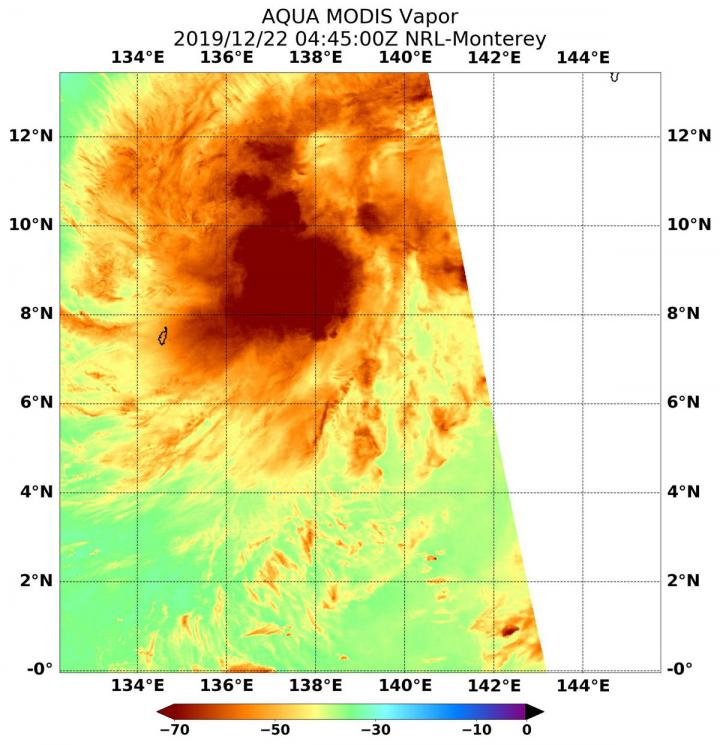
When NASA's Aqua satellite passed over the Northwestern Pacific Ocean, water vapor data gave insights into the intensity of Tropical Cyclone Phanfone or known as Ursula in the Philippines. The tropical depression 30W formed early on Dec. 22 and strengthened into a tropical storm as of 4 am EST and named Phanfone.
The Aqua satellite passed over tropical cyclone on Sunday, Dec. 22 at 0445 UTC (Dec. 21 at 11:45 pm EST) and the Moderate Resolution Imaging Spectroradiometer (MODIS) gathered water vapor content and temperature information indicating the highest concentrations of water vapor and coldest cloud top temperatures around the center of circulation.
Colder temperature means heavy rains
MODIS data revealed the coldest cloud top temperatures colder than minus 70 degrees Fahrenheit (minus 56.6 degrees Celsius) in those storms, which means it has the capability to produce heavy rainfall. The water vapor analysis of tropical cyclones helps researchers to forecast how much would be the potential of a storm.

Water vapor releases latent heat as it condenses into liquid, which in turn forms clouds and thunderstorms that make up a typical tropical cyclone. To determine how strong the storm could be, researchers depend on the temperature. The higher the cloud tops, the colder and the stronger the storms.
On Dec. 23 at 4 am EST, Tropical Storm Phanfone (Ursula) was located near latitude 9.8 degrees north and longitude 132.2 degrees east, about 717 nautical miles east-southeast of Manila, Philippines. Phanfone is currently moving to the west-northwest and had maximum sustained winds near 40 knots (46 mph/74 kph).
Phanfone developing into storm on X-mas Eve
NASA's Aqua satellite is a key NASA satellite that provides data for hurricane research, which helps to forecast a weather event on Earth. On Dec. 23 at 10 a.m. EST, the GMI or Microwave Imager sensor aboard the joint mission of NASA and the Japan Aerospace Exploration Agency's Global Precipitation Measurement or GPM core satellite, showed an eye was developing in Phanfone's center.
Forecasters at the Joint Typhoon Warning Center expect Phanfone predict that the storm will move west-northwest toward and through the central Philippine archipelago and the Visayas and Mindanao regions on Dec. 24 and 25, just before the Christmas celebrations begin.


