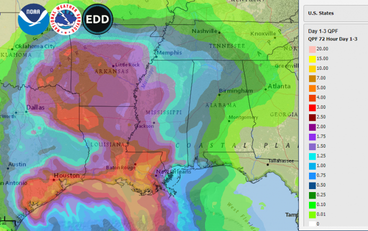
Tropical Storm Beta is likely to bring heavy rainfall as the storm surges with gusty winds hitting parts of Texas and Louisiana, said the National Hurricane Center. The storm conditions were expected to begin Monday, September 21, as the tropical storm is making its way into this part that is already been drenched and damaged due to this year's exceptionally busy hurricane season.
As per an NHC advisory, up to 15 inches (38 centimeters) of rain could fall in some areas that are down from earlier predictions of up to 20 inches (51 centimeters). The National Weather Service noted that "rainfall will also spread northward into the ArkLaTex region and east into the lower Mississippi Valley and portions of the Southeast through the end of the week. Flash, urban, and isolated minor river flooding are possible."
However, on Monday morning maximum sustained winds also decreased to 50 mph and as per the forecast, tropical storm Beta has been on its way to the west at 6mph (9kph). The storm is expected to make landfall along Texas's central and upper Gulf Coast on Monday night. As per the forecasters, Beta would move to northeastward along the coast and then head inro Louisiana in the mid-week.
The NWS said in its advisory, "There is the danger of life-threatening storm surge near times of high tide through Tuesday [September 22] along portions of the Texas and Louisiana coasts within the storm surge warning areas." It also asked people who are residents of these areas to follow the advice given by their local officials.

As per the forecast, tropical storm Beta will continue to result in a high risk of dangerous rip currents along the coast. The authorities have flagged high alert for Alabama and Florida beaches from Monday till Thursday night, September 24.
The authorities have urged people to use extreme caution if visiting the beaches—Dauphin Island, Fort Morgan, Gulf Shores, Orange Beach, Pensacola Beach, Navarre Beach, Fort Walton Beach and Destin Beach. In case someone caught in a rip current, they are advised:
- Not to fight the current
- Swim out of the current and then to the shore
- If can't escape, float or tread water
- Call or wave for assistance
As per the forecasters, the tropical storm was not expected to bring some amount of rainfall in Texas that was noticed during Hurricane Harvey in 2017—that caused $125 billion in damage—or Tropical Storm Imelda in 2019, which was one of the wettest cyclones on record.
NWS said that the tropical storm Beta was churning slowly through the Gulf of Mexico on Monday morning about 110 miles south of Galveston, and 95 miles east-southeast of Port O'Connor, Texas.
As per Houston Mayor Sylvester Turner, even though Beta was not expected to bring rain like Harvey. He said, "Be weather aware because things can change. This is 2020 and so we have to expect the unexpected."
If Beta causes landfall in Texas, it would be the ninth named storm to cause the destruction in the continental US in 2020.
As for Hurricane Teddy that was forecast to move east of Bermuda on Monday, NWS said, "Teddy is expected to transition to a powerful post-tropical cyclone as it moves near or over portions of Atlantic Canada late Tuesday through Thursday, where there is an increased risk of direct impact from wind, rain, and storm surge."
It also noted that large swell produced by Hurricane Teddy are expected to affect portions of Bermuda, the east coast of the US, and Atlantic Canada during the next few days.


